
India is a land of mighty rivers that have shaped its civilization, agriculture, culture, and economy for thousands of years. From the sacred Ganga in the north to the mighty Godavari in the south, India’s rivers serve as lifelines — providing water for irrigation, drinking, transport, and hydroelectric power, while also holding deep spiritual significance. This is why almost every major Indian city is located along the banks of a river.
For students preparing for SSC, UPSC, Railways, and state PSC exams, the rivers of India are one of the most important topics in the geography section. This guide explains the two main river systems, the major rivers in each, their origins, lengths, and tributaries, along with the key facts examiners love to ask.
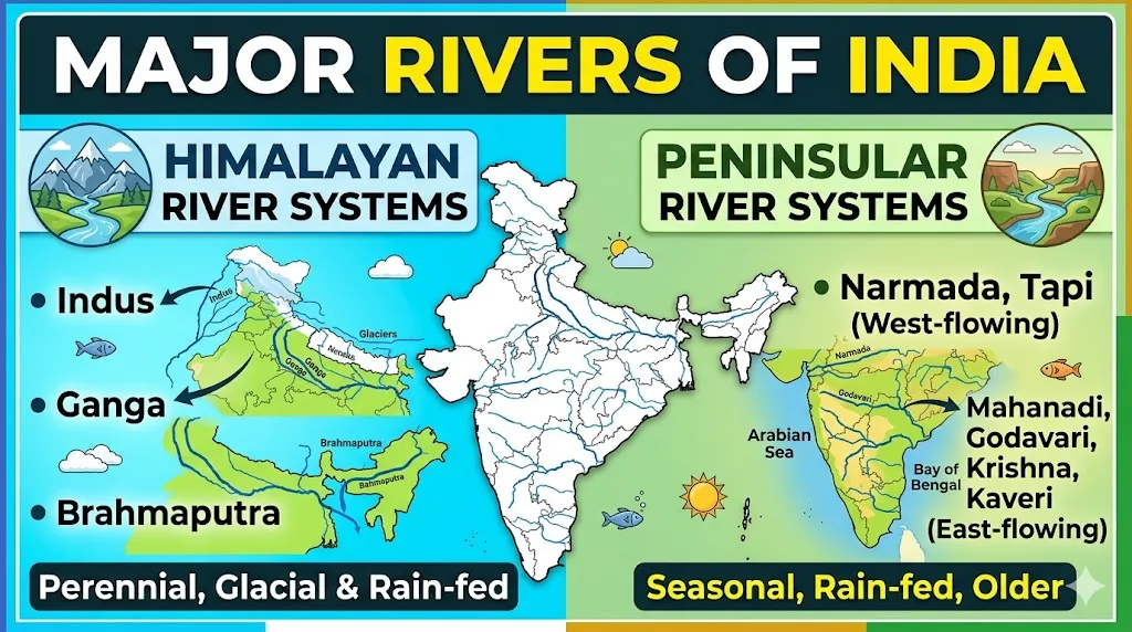
Two Main River Systems of India
India’s rivers are broadly classified into two groups:
- Himalayan Rivers — originate from the Himalayas, are snow-fed, and flow throughout the year (perennial). Because they are fed by both glaciers and rain, they often cause seasonal floods. The major Himalayan river systems are the Indus, Ganga, and Brahmaputra.
- Peninsular Rivers — originate from the plateaus and hills of peninsular India, are mostly rain-fed, and many are seasonal. They flow through fixed paths, do not form large meanders, and have reached a mature stage. The major peninsular rivers include the Godavari, Krishna, Kaveri, Mahanadi, Narmada, and Tapi.
An interesting fact: the peninsular drainage system is older than the Himalayan drainage system, evident from the mature stage of the rivers and their broad, shallow valleys.
Himalayan River Systems
1. The Indus River System
The Indus is one of the longest rivers in Asia. It rises near Lake Mansarovar in Tibet and flows through Ladakh before entering Pakistan. Its main tributaries in India include the Jhelum, Chenab, Ravi, Beas, and Sutlej — which is why the region is called “Punjab” (land of five rivers). The Indus eventually drains into the Arabian Sea.
2. The Ganga River System
The Ganga is the longest river within India and its most sacred. It is formed at Devprayag by the meeting of the Bhagirathi and Alaknanda rivers and enters the plains at Haridwar.
- Northern (Himalayan) tributaries: Yamuna, Ghaghara, Gandak, and Kosi. The Kosi is known as the “Sorrow of Bihar” because of its destructive floods.
- Southern (peninsular) tributaries: Son, Chambal, Betwa, and Ken (these join via the Yamuna).
The Yamuna, the Ganga’s most important tributary, originates from the Yamunotri glacier and flows roughly parallel to the Ganga. The Ganga finally drains into the Bay of Bengal, forming the world’s largest delta (the Sundarbans) along with the Brahmaputra.
3. The Brahmaputra River System
The Brahmaputra has the greatest volume of water of all rivers in India. It originates from the Angsi/Chemayungdung glacier near Lake Mansarovar in Tibet, where it is known as the Tsangpo. It enters India in Arunachal Pradesh (where it is called the Dihang), then flows through Assam as the Brahmaputra, before entering Bangladesh and joining the Ganga. Its major tributaries include the Dibang, Lohit, Subansiri, Kameng, and Tista. At over 2,900 km long, it is one of the longest trans-boundary rivers in the world.
Peninsular River Systems
1. The Godavari River
The Godavari is the largest and longest peninsular river and the second-longest river in India after the Ganga, with a length of about 1,465 km. It rises in the Western Ghats near Nashik in Maharashtra and drains into the Bay of Bengal. Because of its size and significance, it is often called the “Dakshin Ganga” (Ganga of the South). Its basin is the largest among peninsular rivers, and its tributaries include the Pravara, Manjira, Indravati, and Sabari.
2. The Krishna River
The Krishna is the second-largest peninsular river, flowing about 1,400 km. It rises near Mahabaleshwar in the Western Ghats and flows through Maharashtra, Karnataka, Telangana, and Andhra Pradesh before reaching the Bay of Bengal. Its largest tributary is the Tungabhadra, while its longest tributary is the Bhima.
3. The Kaveri (Cauvery) River
The Kaveri rises in the Brahmagiri range of the Western Ghats in Karnataka and flows through Karnataka and Tamil Nadu before draining into the Bay of Bengal near Cuddalore. It has a length of about 760–800 km. Its main tributaries include the Amravati, Bhavani, Hemavati, and Kabini. The Kaveri is famous for its rich delta, often called the “rice bowl of South India.”
4. The Mahanadi River
The Mahanadi rises in the highlands of Chhattisgarh and flows through Odisha to reach the Bay of Bengal, covering about 858 km. It is known for depositing more silt than almost any other river in the subcontinent. The Hirakud Dam, one of the longest dams in the world, is built on the Mahanadi.
5. The Narmada River
The Narmada is unusual because it flows east to west, unlike most peninsular rivers. It rises in the Amarkantak hills in Madhya Pradesh and flows through a rift valley before draining into the Arabian Sea (Gulf of Khambhat). It covers about 1,312 km. The Sardar Sarovar Dam is built on the Narmada.
6. The Tapi (Tapti) River
The Tapi also flows east to west, parallel to the Narmada, through a rift valley. It rises in the Satpura ranges in Madhya Pradesh and flows through Maharashtra and Gujarat before draining into the Arabian Sea. Its major tributaries include the Purna, Girna, and Panjhra.
Why Indian Rivers Are Important
India’s rivers are central to the country’s survival and growth:
- Irrigation: The Ganga plain and Godavari-Krishna basins are India’s granaries. Large canals like the Indira Gandhi Canal distribute river water across states.
- Hydroelectricity: Major dams such as Bhakra-Nangal (Sutlej), Tehri (Bhagirathi), Hirakud (Mahanadi), and Sardar Sarovar (Narmada) generate power for millions.
- Drinking water: Most cities and villages draw water from rivers or their reservoirs.
- Biodiversity and culture: River basins support rich ecosystems, and many rivers hold deep religious significance.
Quick Facts to Remember for Exams
- Longest river in India: Ganga
- Largest river by water volume: Brahmaputra
- Longest/largest peninsular river: Godavari (“Dakshin Ganga”)
- Rivers flowing east to west: Narmada, Tapi (and Mahi)
- Most peninsular rivers drain into the Bay of Bengal; Narmada and Tapi drain into the Arabian Sea.
- Indus tributaries: Jhelum, Chenab, Ravi, Beas, Sutlej
- “Sorrow of Bihar”: Kosi river
Conclusion
India’s rivers, divided into the perennial Himalayan systems and the largely seasonal peninsular systems, are the true lifelines of the nation. The Ganga, Brahmaputra, and Indus dominate the north, while the Godavari, Krishna, Kaveri, Mahanadi, Narmada, and Tapi shape the peninsula. Together they sustain agriculture, generate power, support biodiversity, and carry deep cultural meaning.
For competitive exam aspirants, knowing each river’s origin, course, tributaries, and key facts — especially the longest, largest, and east-flowing rivers — is essential, as questions on Indian rivers appear regularly in the geography section. Bookmark this page and revise it alongside a river map of India for the best results.
Note: River lengths can vary slightly across sources. Always cross-check with standard geography references and official sources.
Refe is an education writer with over 6 years of experience covering government jobs, competitive exams, and scholarships across India. He writes for REFE JOB to help students and aspirants — from Jammu & Kashmir to Tamil Nadu — get accurate, free, and timely information about SSC, IBPS, UPSC, JKSSB, and state recruitment boards. Every post is sourced from official notifications and government portals.